The geographical location of the Incas constitutes one of the most physically diverse and challenging territories ever managed by a pre industrial civilization. Historically, the geographic location of the Inca Empire was not defined by a single landscape, but by a mastery of the “vertical ecology” of the Andes Mountains. Extending along the western coast of South America, the geographical location of the Inca encompassed a land area of more than 2 million square kilometers (approx. 770,000 square miles) at its peak between 1438 and 1533 AD. This territory was larger than the Roman Empire at its zenith, stretching across a continent driven by tectonic activity and climatic extremes.
Explain the geographical location of the Inca Empire in South America.
To accurately describe the geographic location of the Inca Empire, one must look to the longitudinal expansion along the Pacific Ring of Fire. The geographic location of the Incas stretched approximately 4,000 kilometers (2,500 miles) from north to south, making it the longest empire in the pre Columbian Americas.
The geographic location of the Inca Empire was bounded by the Pacific Ocean to the west and the dense Amazon Rainforest to the east. This positioning allowed the civilization to control a massive corridor of land that acted as the cultural and economic spine of the continent. The coordinates roughly spanned from the Ancasmayo River in southern Colombia (1° N latitude) down to the Maule River in central Chile (36° S latitude), creating a state that functioned across both the Northern and Southern Hemispheres.
The Six Modern Countries Included in the Geographical Location of the Inca
The sheer magnitude of the empire’s dominion is best understood by overlaying it onto a modern political map. The ancient geographical location of the Inca territory was so vast that today it encompasses the borders of six distinct South American nations. If you were to traverse the geographic location of the Inca Empire today, your journey would take you through:
-
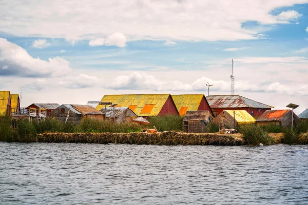
Peru: The beating heart and cradle of the civilization. This region housed the imperial capital, Cusco (“The Navel of the World”), and the Sacred Valley, which served as the agricultural engine for the nobility. It was the administrative core from which all roads radiated.
-
Ecuador: Far more than just a province, the northern highlands became a rival seat of power. Under the Emperor Huayna Capac, the city of Quito (and nearby Tomebamba) grew into a second capital, eventually leading to the civil war that fractured the empire just before the Spanish arrival.
-
Bolivia: This region represented the spiritual and economic backbone of the south. It encompasses the high altitude Altiplano and Lake Titicaca, revered as the mythological birthplace where the first Incas, Manco Cápac and Mama Ocllo, emerged. It was also the empire’s primary source of mineral wealth and llama herds.
-
Chile: The Inca presence here stretched across the unforgiving Atacama Desert the driest on Earth down into the fertile Mediterranean valleys of the central region. The expansion halted at the Maule River, where the fierce resistance of the Mapuche people established the empire’s southern military frontier.
-
Argentina: The empire extended deep into the mountainous northwest (provinces of Jujuy, Salta, Tucumán, and Catamarca). This area was crucial for the Qhapaq Ñan road network and is famous today for its high altitude mountaintop shrines, where the Incas performed sacred Capacocha ceremonies on peaks like Llullaillaco.
-
Colombia: Marking the northernmost limit of the geographic location of the Inca Empire, this territory reached the Ancasmayo River (near modern day Pasto). This river served as a natural border, marking the point where the Andean production zones began to fade into the tropical northern Andes.
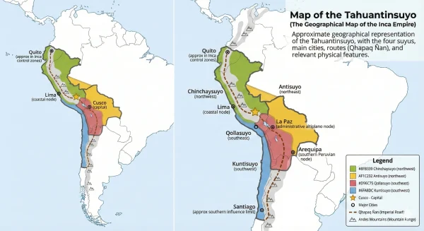
How the Four Suyos Defined the Geographic Location of the Inca Empire
The Incas didn’t just rule a random collection of lands; they engineered a unified world known as Tahuantinsuyo Quechua for “The Four Regions Together.” To understand the organization of the geographic location of the Inca Empire, you must look to Cusco. The city wasn’t just a capital; it was the axis of the universe. From the central plaza of Haukaypata, four great roads radiated outward, physically dividing the geographical location of the Incas into four distinct administrative quarters (Suyos), each with its own climate, culture, and economic role:
-
Chinchaysuyo (The Northern Quarter): Stretching north through modern day Peru and Ecuador, this was the wealthiest and most populous sector of the empire. It served as the agricultural powerhouse and the source of the sacred Spondylus shell (mullu), a crimson shell valued more highly than gold for its role in rain rituals. In the empire’s final years, this region became a rival power base to Cusco itself.
-
Collasuyo (The Southern Quarter): Exploring the geographical location of the Incas to the south reveals the largest of the four regions. Encompassing the vast Altiplano of Bolivia, Chile, and Argentina, this was the “Land of the Aymara.” It was the empire’s industrial spine, supplying massive herds of llamas for transport, alpacas for fine textiles, and the rich mineral veins (silver and copper) of the southern Andes.
-
Antisuyo (The Eastern Quarter): To the east lay the mysterious, green frontier of the Amazon cloud forest. This was the wildest part of the geographic location of the Inca Empire. It was a challenging terrain that supplied the nobility with exotic luxuries unavailable in the mountains: vibrant macaw feathers for ceremonial headdresses, medicinal plants, abundant gold, and the sacred coca leaf, essential for Andean rituals.
-
Contisuyo (The Western Quarter): Though geographically the smallest, this region covering the arid Pacific coast was strategically vital. It connected the high Andes to the ocean. Here, the Incas managed the productive fisheries and harvested guano fertilizer that fueled the agricultural terraces of the highlands, proving how interconnected the diversified geographical location of the Incas truly was.
Physical Features Defining the Geographical Location of the Incas

To truly understand the geographic location of the Incas, you must discard the European notion of territory. Most great civilizations, like those in Egypt or Mesopotamia, grew horizontally along fertile river valleys. The geographical location of the Inca was radically different: it was a vertical empire. They were the masters of the “ecological staircase.”
The empire didn’t just span distance; it spanned altitudes. The geographical location of the Inca forced them to simultaneously manage three distinct parallel worlds that usually exist thousands of miles apart:
-
The Costa (Coast): A strip of hyper arid desert created by the cold Humboldt Current, yet rich in marine life.
-
The Sierra (Highlands): The jagged, frozen spine of the Andes where the air is thin and the sun is intense.
-
The Selva (Jungle): The hot, humid eastern slopes that plunge into the Amazon basin. This unique diversity meant that the geographic location of the Incas contained nearly every climate zone known to science, requiring a society that could navigate from glacial peaks to steaming rainforests in a matter of days.
The Andes Mountains as the Backbone of the Geographic Location of the Inca Empire
The Andes are not just a feature of the landscape; they are the skeletal structure that held the entire civilization together. Rising to dizzying heights of over 6,000 meters (20,000 feet), this range defines the geographic location of the Inca Empire.
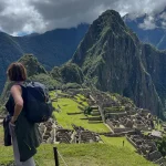
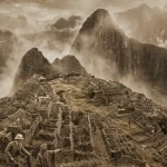
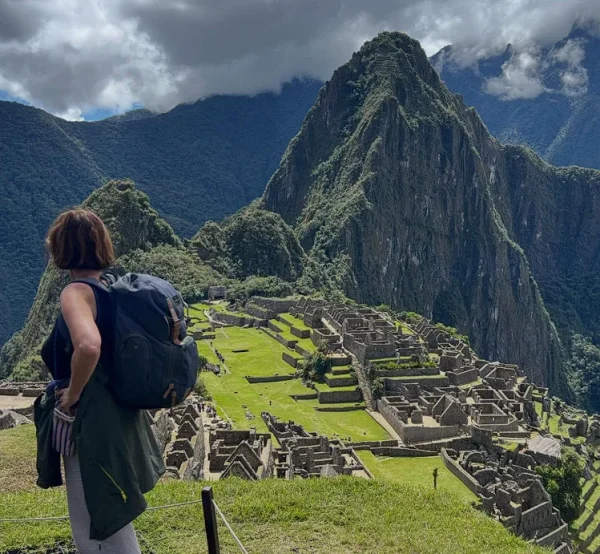
To describe the geographic location of the Inca Empire is to describe a life lived in the clouds. While other cultures saw mountains as barriers to be avoided, the Incas saw them as the safest place to build. Major cities like Cusco (3,400 meters / 11,150 feet) and Machu Picchu (2,430 meters / 7,970 feet) were engineered directly onto ridges and fault lines. This high-altitude positioning provided natural fortification against invasion and granted control over the headwaters of the continent’s rivers.
But for the Incas, the geographic location of the Inca Empire was also spiritual. These mountains were not inanimate rock; they were Apus powerful deities. The Incas believed that the physical landscape itself dictated their fate, controlling the weather, the water flow, and the fertility of the valleys below. They didn’t just inhabit the geography; they revered it.
Coastal Deserts and Amazon Jungle in the Geographical Location of the Inca
The geographical location of the Inca was defined by a dramatic climatic paradox. To the west, the empire dominated the coastal strip, including the Atacama Desert, one of the driest places on Earth. This aridity is caused by the cold Humboldt Current, which cools the ocean air, preventing rain clouds from forming. Yet, the Incas turned this barren land into a breadbasket by engineering massive irrigation canals that brought glacial meltwater down to the sand, cultivating cotton and corn in the middle of a desert.
Conversely, the eastern border of the geographic location of the Inca Empire plunges into the steaming “Eyebrow of the Jungle” (Ceja de Selva). Here, the massive wall of the Andes creates a “rain shadow” effect: the mountains block the moisture rising from the Amazon basin, drenching the eastern slopes while leaving the western coast dry. The Incas navigated these extremes by mastering a trade network that defied the terrain. They imported nutrient rich guano fertilizer from the coastal islands to the high mountains, and brought sacred coca leaves, exotic feathers, and gold up from the Amazon jungle, uniting two worlds that should never have met.
The Strategic Importance of the Geographic Location of the Incas
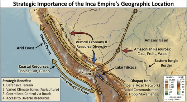
The geographic location of the Incas was not just a challenge to be overcome; it was their greatest strategic weapon. By occupying the high watershed of the Andes, they effectively sat at the “top of the tap,” controlling the source of every major river flowing west to the Pacific and east to the Amazon. When historians describe the geographic location of the Inca Empire, they emphasize its resilience. While coastal civilizations were vulnerable to the devastating floods of El Niño or prolonged droughts, the Incas had an ecological insurance policy. Their vertical control allowed for a diversified economy. If a frost killed the potatoes at 4,000 meters, the corn at 2,000 meters would survive. If a drought hit the mountains, the irrigated valleys of the coast could still produce food. This geographic diversity created a safety net that made the Inca economy one of the most stable and famine resistant in the ancient world.
Adapting Agriculture to the Vertical Geographical Location of the Inca
Survival in the rugged geographical location of the Inca was a constant battle against gravity and climate. Since flat, arable land was virtually non existent in the Andes, the Incas geo engineered the mountains themselves. They carved the steep slopes into massive staircases known as Andenes (agricultural terraces).
This wasn’t just farming; it was climate science. By using the “vertical archipelago” model, they adapted to the diverse geographic location of the Inca Empire. The stone walls of the terraces absorbed heat during the day and released it at night, preventing frost and allowing them to grow crops at altitudes where they naturally wouldn’t survive. This allowed them to stack different production zones on top of each other:
-
The Quechua Zone (2,300–3,500m): The breadbasket for corn (maize).
-
The Suni Zone (3,500–4,000m): The domain of the potato and quinoa.
-
The Puna Zone (4,000m+): The high grasslands reserved for grazing llamas and alpacas. By maximizing every vertical meter, they turned the hostile geographical location of the Incas into one of the most productive agricultural systems in the ancient world.
The Qhapaq Ñan Road System Across the Geographic Location of the Inca Empire
An empire is only as strong as its ability to communicate. The immense scale of the geographic location of the Inca Empire necessitated a “nervous system” to connect the head (Cusco) to the rest of the body. The solution was the Qhapaq Ñan (The Royal Road).
Spanning over 30,000 kilometers (18,600 miles), this engineering marvel stitched together the fragmented geographical location of the Incas. It conquered terrain that would terrify modern engineers. Where the mountains were too steep, they carved stairs into the living rock. Where canyons were too deep, they wove suspension bridges out of sturdy Ichu grass.
This infrastructure ensured that the administrative reach of the Emperor extended to the farthest borders. It allowed the Chasquis highly trained relay runners to cover hundreds of kilometers a day. Thanks to this road network, a message (or a fresh fish from the sea) could travel across the challenging geographic location of the Inca Empire faster than a horseman could travel in colonial times, relying on a system of Tambos (rest houses) spaced perfectly one day’s run apart.
frequently asked questions
Today, the vast geographical location of the Incas overlaps with the sovereign territories of six modern nations. The geographic location of the Inca Empire encompassed:
-
Peru: The imperial core, containing the capital (Cusco) and the Sacred Valley.
-
Ecuador: The northern military powerhouse, centered around Quito.
-
Bolivia: The resource-rich Altiplano and southern mining hub.
-
Chile: The northern deserts and central fertile valleys up to the Maule River.
-
Argentina: The rugged northwest Andes (provinces of Tucumán, Salta, and Jujuy).
-
Colombia: The northern frontier at the Ancasmayo River (near Pasto).
The rugged topography of the geographic location of the Inca Empire made traditional horizontal farming impossible. To survive, the Incas engineered the “Vertical Archipelago” system. They carved the mountains into Andenes (terraces) to create artificial microclimates. This adaptation to the geographical location of the Inca allowed them to cultivate maize at 3,000 meters and potatoes at 4,000 meters, effectively turning the mountains into a layered food production machine that defied the risks of frost and drought.
At its imperial zenith (approx. 1525 AD), the boundaries of the geographical location of the Inca were defined by natural barriers rather than political lines:
-
North: The Ancasmayo River (modern Colombia).
-
South: The Maule River (modern Chile), where expansion was halted by the Mapuche resistance.
-
West: The Pacific Ocean (Mama Cocha), providing marine resources.
-
East: The dense Amazon Rainforest (Antisuyo), which served as an impenetrable green wall limiting eastward expansion.